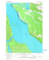
1961 Map of Petersburg D-3
USGS Topo · Published 1967About this map
Petersburg and its smaller counterpart West Petersburg anchor this coastal survey, where the maritime and industrial character of Southeast Alaska is clearly defined. Along the Wrangell Narrows, critical transportation infrastructure is mapped, including a Ferry Terminal and Seaplane Anchorage, alongside local landmarks like a Ski Lift and an Aqueduct on Mitkof Island. The map records the early footprint of the Mitkof Highway leading south past Doyhof and Scow Bay. To the north, the massive ice flow of Patterson Glacier feeds the Patterson River and Muddy River, illustrating the direct connection between the glacial interior and the coastal inlets of Frederick Sound. This 1961 field-annotated record provides a detailed view of the region's development before the expansion of modern infrastructure, noting a small Cem and a Quarry near the primary settlement.
Find a feature on this map
59 named features on this map. Tap any name to fly to it.
Don’t see what you’re looking for? This feature index may not catch every label — zoom into the map to look around manually.
Map Details
Editions of this 1961 Petersburg D-3 Map
3 editions found

Other maps of this area

1948 · Sumdum A-4
USGS Topo · 1:63,360

1948 · Petersburg C-4
USGS Topo · 1:63,360

1948 · Petersburg C-2
USGS Topo · 1:63,360

1948 · Petersburg C-3
USGS Topo · 1:63,360

1951 · Petersburg D-4
USGS Topo · 1:63,360

1951 · Petersburg C-4
USGS Topo · 1:63,360

1951 · Sumdum A-4
USGS Topo · 1:63,360

1951 · Petersburg C-2
USGS Topo · 1:63,360

1952 · Petersburg
USGS Topo · 1:250,000

1952 · Sumdum
USGS Topo · 1:250,000