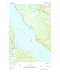
1961 Map of Petersburg D-3
USGS Topo · Published 1983About this map
Petersburg sits at the northern tip of Mitkof Island, serving as the primary hub for the region where Wrangell Narrows meets the expansive Frederick Sound. This 1960s-era record reveals the maritime and recreational infrastructure of the time, including a Ferry Terminal, Seaplane Anchorage, and a Ski Lift south of the town center. Across the narrows on Kupreanof Island, the small settlement of Doyhof is visible alongside the shoreline of Lindenberg Peninsula.
Find a feature on this map
57 named features on this map. Tap any name to fly to it.
Don’t see what you’re looking for? This feature index may not catch every label — zoom into the map to look around manually.
Map Details
Editions of this 1961 Petersburg D-3 Map
3 editions found

Other maps of this area

1948 · Sumdum A-4
USGS Topo · 1:63,360

1948 · Petersburg C-4
USGS Topo · 1:63,360

1948 · Petersburg C-2
USGS Topo · 1:63,360

1948 · Petersburg C-3
USGS Topo · 1:63,360

1951 · Petersburg D-4
USGS Topo · 1:63,360

1951 · Petersburg C-4
USGS Topo · 1:63,360

1951 · Sumdum A-4
USGS Topo · 1:63,360

1951 · Petersburg C-2
USGS Topo · 1:63,360

1952 · Petersburg
USGS Topo · 1:250,000

1952 · Sumdum
USGS Topo · 1:250,000