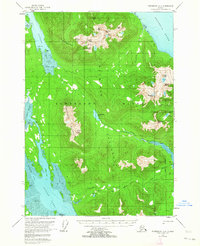
1951 Map of Petersburg D-4
USGS Topo · Published 1963About this map
Kupreanof Island presents a landscape of deep glacial fjords and high peaks within the Tongass National Forest during the early 1950s. The topographic detail reveals the rugged separation of the Lindeberg Peninsula from the main island mass, connected by the drainage of Petersburg Creek and Petersburg Lake. Maritime activity is evidenced by the Indian Pt CAA Sta Tanks and several cabins located along the shoreline of Duncan Canal and Portage Bay. The map documents the intricate coastline of McDonald Arm and Towers Arm, where the dramatic tidal fluctuations are marked by extensive tidal flats. This survey, based on 1948 photography, captures the wilderness character of the Missionary Range before significant modern development, preserving the locations of early trails and remote coastal outposts used by hunters and early settlers.
Find a feature on this map
51 named features on this map. Tap any name to fly to it.
Don’t see what you’re looking for? This feature index may not catch every label — zoom into the map to look around manually.
Map Details
Editions of this 1951 Petersburg D-4 Map
4 editions found
Other maps of this area

1948 · Sumdum A-4
USGS Topo · 1:63,360

1948 · Sumdum A-5
USGS Topo · 1:63,360

1948 · Petersburg C-4
USGS Topo · 1:63,360

1948 · Petersburg C-3
USGS Topo · 1:63,360

1948 · Petersburg C-5
USGS Topo · 1:63,360

1948 · Petersburg D-5
USGS Topo · 1:63,360

1951 · Petersburg D-4
USGS Topo · 1:63,360

1951 · Petersburg C-4
USGS Topo · 1:63,360

1951 · Sumdum A-4
USGS Topo · 1:63,360

1951 · Petersburg C-5
USGS Topo · 1:63,360