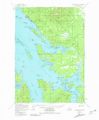
1951 Map of Petersburg D-6
USGS Topo · Published 1980About this map
Kake and the surrounding coastline of Kupreanof Island are depicted here during the mid-century, a period when the local economy was anchored by maritime industry and subsistence. The presence of a Cannery and Wharf at the northern edge of the map, near the mouth of Gunnuk Creek, underscores the historic importance of salmon and commercial fishing to this region. The landscape is a complex network of waterways, from the broad Keku Strait to the intricate passages of Rocky Pass and Hamilton Bay.
Find a feature on this map
55 named features on this map. Tap any name to fly to it.
Don’t see what you’re looking for? This feature index may not catch every label — zoom into the map to look around manually.
Map Details
Editions of this 1951 Petersburg D-6 Map
3 editions found

Other maps of this area

1948 · Port Alexander C-1
USGS Topo · 1:63,360

1948 · Sumdum A-5
USGS Topo · 1:63,360

1948 · Sumdum A-6
USGS Topo · 1:63,360

1948 · Petersburg D-6
USGS Topo · 1:63,360

1948 · Port Alexander D-1
USGS Topo · 1:63,360

1948 · Petersburg C-6
USGS Topo · 1:63,360

1948 · Sitka A-1
USGS Topo · 1:63,360

1948 · Petersburg C-5
USGS Topo · 1:63,360

1948 · Petersburg D-5
USGS Topo · 1:63,360

1951 · Sitka
USGS Topo · 1:250,000