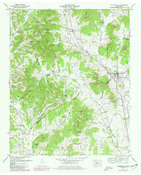
1951 Map of Petersburg
USGS Topo · Published 1980About this map
Richland Creek and Cane Creek drain a landscape of steep hollows and narrow ridges along the Marshall Co Lincoln Co line. The settlement of Petersburg serves as a local hub near Gaunt Hill, while smaller communities like Wakefield, Delina, and Blakelyville are connected by winding valley roads. The area is dense with family history, evidenced by dozens of small burial grounds such as Old Orchard Cem, Leonard Cem, and Sowell Cem that dot the hillsides. The mid-century rural infrastructure is visible through landmarks like Morgan Sch and Cane Creek Church. Topographical features such as Petty Cave and the prominent Poplar Ridge define the terrain, illustrating the tight relationship between the limestone geology and the placement of early Tennessee farmsteads.
Find a feature on this map
100 named features on this map. Tap any name to fly to it.
Don’t see what you’re looking for? This feature index may not catch every label — zoom into the map to look around manually.
Map Details
Editions of this 1951 Petersburg Map
3 editions found
Other maps of this area

1936 · Belfast
USGS Topo · 1:24,000

1936 · Cornersville
USGS Topo · 1:24,000

1936 · Lewisburg
USGS Topo · 1:24,000

1936 · Belleville
USGS Topo · 1:24,000

1936 · Boonshill
USGS Topo · 1:24,000

1936 · Petersburg
USGS Topo · 1:24,000

1936 · Bedford
USGS Topo · 1:24,000

1936 · Frankewing
USGS Topo · 1:24,000

1936 · Fayetteville
USGS Topo · 1:24,000

1944 · Shelbyville
USGS Topo · 1:100,000