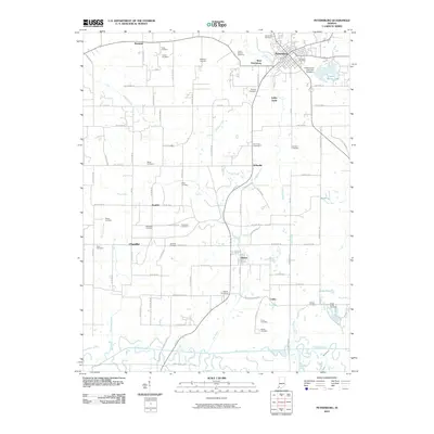
2010 Map of Petersburg
USGS Topo · Published 2010About this map
Petersburg sits at the northern edge of this landscape, flanked by the Patoka River to the south and a complex network of creeks. The region is marked by a high density of small family and community burial grounds, such as Indian Mound Cemetery and the Loveless Cemetery, suggesting a deeply rooted rural population. Industrial activity is evident at Ashby Yards, while the southern reaches of the map show the influence of water management at Prides Creek Lake Dam Number 4 and Globe Pond. Small settlements like Willisville, Glezen, and Littles are interconnected by a grid of county roads and rail corridors, reflecting the area's agricultural and transit-oriented layout. The terrain is defined by the winding paths of Flat Creek, Robinson Creek, and Sugar Creek, which feed into the primary river valley at the bottom of the sheet.
Find a feature on this map
90 named features on this map. Tap any name to fly to it.
Don’t see what you’re looking for? This feature index may not catch every label — zoom into the map to look around manually.
Map Details
Editions of this 2010 Petersburg Map
This is the sole edition of this map. No revisions or reprints were ever made.
Other maps of this area

1902 · Ditney
USGS Topo · 1:125,000

1903 · Velpen
USGS Topo · 1:62,500

1903 · Petersburg
USGS Topo · 1:62,500

1944 · Monroe City
USGS Topo · 1:24,000

1944 · Iona
USGS Topo · 1:24,000

1945 · Sandy Hook
USGS Topo · 1:24,000

1956 · Vincennes
USGS Topo · 1:250,000

1957 · Vincennes
USGS Topo · 1:250,000

1958 · Vincennes
USGS Topo · 1:250,000
1958 · Monroe City
USGS Topo · 1:24,000