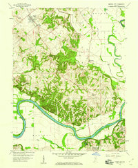
1958 Map of Monroe City
USGS Topo · Published 1959About this map
The White River carves a dramatic southern boundary through this landscape, creating the prominent Sevenmile Bend and supporting a river-and-rail economy near the mid-century. The New York Central railroad parallels the river's path, connecting the settlement of Petersburg to the surrounding agricultural and industrial districts. The upland terrain is defined by the Beech Hills, where several rural landmarks are scattered, including Hamline Chapel, Wilson Creek Ch, and the Freeland Cem. To the north, Monroe City sits near the intersection of several local routes at Five Points. The presence of numerous Oil Wells and a Strip Mine in the eastern portion of the map indicates the region's reliance on mineral extraction during this era, while the extensive system of drainage projects like Kessinger Ditch and Patrick Ditch highlights the transformation of the bottomlands for farming.
Find a feature on this map
38 named features on this map. Tap any name to fly to it.
Don’t see what you’re looking for? This feature index may not catch every label — zoom into the map to look around manually.
Map Details
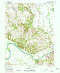
Editions of this 1958 Monroe City Map
2 editions found
Other maps of this area

1902 · Ditney
USGS Topo · 1:125,000

1903 · Velpen
USGS Topo · 1:62,500

1903 · Petersburg
USGS Topo · 1:62,500

1942 · Fritchton
USGS Topo · 1:24,000

1944 · Fritchton
USGS Topo · 1:24,000

1944 · Washington
USGS Topo · 1:24,000

1944 · Monroe City
USGS Topo · 1:24,000

1944 · Wheatland
USGS Topo · 1:24,000

1944 · Iona
USGS Topo · 1:24,000

1945 · Sandy Hook
USGS Topo · 1:24,000