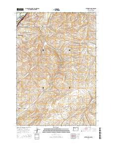
2014 Map of Petersburg
USGS Topo · Published 2014About this map
Petersburg sits at the heart of this agricultural and riparian landscape southeast of The Dalles, where the terrain transitions from the Columbia River banks toward the high ridges of the Mount Hood National Forest. The map documents a deeply carved drainage system defined by Fifteenmile Creek, Eightmile Creek, and Fivemile Creek, which flow toward the Columbia. Along the northern edge, the waters of Lake Celilo surround the significant site of Memaloose Island, marked here by the Viewpoint Grave Island Memorial. For those tracing local families, the survey provides precise locations for the Petersburg Cemetery, Eightmile Cemetery, and Rice Cemetery. The interior is marked by named geographic depressions and rises including Japanese Hollow, Company Hollow, and the prominent Signal Hill, reflecting a landscape of long-established ranching and orchard culture.
Find a feature on this map
43 named features on this map. Tap any name to fly to it.
Don’t see what you’re looking for? This feature index may not catch every label — zoom into the map to look around manually.
Map Details
Editions of this 2014 Petersburg Map
This is the sole edition of this map. No revisions or reprints were ever made.
Other maps of this area

1930 · Dufur
USGS Topo · 1:125,000

1934 · Dufur
USGS Topo · 1:125,000

1934 · The Dalles
USGS Topo · 1:125,000

1953 · The Dalles
USGS Topo · 1:250,000

1956 · The Dalles
USGS Topo · 1:250,000

1957 · The Dalles
USGS Topo · 1:250,000

1957 · The Dalles
USGS Topo · 1:62,500

1957 · Wishram
USGS Topo · 1:62,500

1962 · Summit Ridge
USGS Topo · 1:24,000

1962 · Dufur East
USGS Topo · 1:24,000