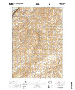
2020 Map of Petersburg
USGS Topo · Published 2020About this map
Fifteenmile Creek and Eightmile Creek carve deep courses through this high-desert plateau east of The Dalles, where the agricultural landscape is defined by long-standing canyon names and small rural hubs. The map shows the small settlements of Petersburg and Fairbanks alongside a network of local thoroughfares like Emerson Loop Rd and Old Dufur Rd. This region has a strong cemetery-based history, with the Petersburg Cemetery, Eightmile Cemetery, and Rice Cemetery serving as vital markers of early homesteading families. To the northwest, the map captures the transition to the Mount Hood National Forest and the Washington border at the Columbia River, featuring the Grave Island Memorial and Cushing Falls. The recurring naming of hollows, such as Japanese Hollow and Company Hollow, reflects the historical usage of these sheltered draws by specific communities and industries.
Find a feature on this map
45 named features on this map. Tap any name to fly to it.
Don’t see what you’re looking for? This feature index may not catch every label — zoom into the map to look around manually.
Map Details
Editions of this 2020 Petersburg Map
This is the sole edition of this map. No revisions or reprints were ever made.
Other maps of this area

1930 · Dufur
USGS Topo · 1:125,000

1934 · Dufur
USGS Topo · 1:125,000

1934 · The Dalles
USGS Topo · 1:125,000

1953 · The Dalles
USGS Topo · 1:250,000

1956 · The Dalles
USGS Topo · 1:250,000

1957 · The Dalles
USGS Topo · 1:250,000

1957 · The Dalles
USGS Topo · 1:62,500

1957 · Wishram
USGS Topo · 1:62,500

1962 · Summit Ridge
USGS Topo · 1:24,000

1962 · Dufur East
USGS Topo · 1:24,000