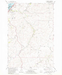
1978 Map of Petersburg
USGS Topo · Published 1978About this map
Lake Celilo and the Columbia River dominate the northern edge of this landscape, shaped by the massive engineering of The Dalles Dam. The terrain rises sharply from the riverbanks into a dissected plateau carved by Fifteenmile Creek, Eightmile Creek, and Fivemile Creek. This 1970s record shows the infrastructure of the era, from the Union Pacific rail lines and the Big Eddy Substation to more rural landmarks like the Grain Elevator at Rice. Smaller settlements like Petersburg and Fairbanks appear amidst an agricultural network of Emerson Loop Road and Old Dufur Road. Genealogists will find particular value in the Grave Island Mem (Cem) and the Eightmile Cem, while the inclusion of Cushing Falls and Petersburg Falls highlights the natural hydrology of the creek systems before they reach the Columbia.
Find a feature on this map
49 named features on this map. Tap any name to fly to it.
Don’t see what you’re looking for? This feature index may not catch every label — zoom into the map to look around manually.
Map Details
Editions of this 1978 Petersburg Map
This is the sole edition of this map. No revisions or reprints were ever made.
Other maps of this area

1930 · Dufur
USGS Topo · 1:125,000

1934 · Dufur
USGS Topo · 1:125,000

1934 · The Dalles
USGS Topo · 1:125,000

1953 · The Dalles
USGS Topo · 1:250,000

1956 · The Dalles
USGS Topo · 1:250,000

1957 · The Dalles
USGS Topo · 1:250,000

1957 · The Dalles
USGS Topo · 1:62,500

1957 · Wishram
USGS Topo · 1:62,500

1962 · Summit Ridge
USGS Topo · 1:24,000

1962 · Dufur East
USGS Topo · 1:24,000