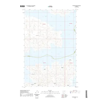
2020 Map of Peterson Point
USGS Topo · Published 2020About this map
Fort Peck Lake dominates this landscape on the border of Valley and Garfield counties, where the Missouri River's impoundment has created a complex shoreline of deep bays and finger-like peninsulas. The northern portion of the map is defined by the high ground of Harper Ridge and the broad waters of Sutherland Creek Bay. South of the lake, the terrain is deeply dissected by a network of drainage features known locally as coulees. These include the descriptively named Cold Turkey Coulee, Rattlesnake Coulee, and Bighorn Coulee. The presence of these named ravines, alongside the Peterson Point promontory and the southern Hell Creek Bay, illustrates the transition from high prairie ridges to the massive reservoir's edge in a region where geography and water management are fundamentally linked.
Find a feature on this map
18 named features on this map. Tap any name to fly to it.
Don’t see what you’re looking for? This feature index may not catch every label — zoom into the map to look around manually.
Map Details
Editions of this 2020 Peterson Point Map
This is the sole edition of this map. No revisions or reprints were ever made.
Other maps of this area

1954 · Jordan
USGS Topo · 1:250,000

1956 · Jordan
USGS Topo · 1:250,000

1958 · Jordan
USGS Topo · 1:250,000

1958 · Collins Ranch
USGS Topo · 1:62,500

1958 · Maloney Hill
USGS Topo · 1:62,500

1964 · Jordan
USGS Topo · 1:250,000

1971 · Trumbo Ranch
USGS Topo · 1:24,000

1971 · Harper Camp
USGS Topo · 1:24,000
1973 · Murray Hill
USGS Topo · 1:24,000

1978 · Fort Peck Lake West
USGS Topo · 1:100,000