1963 Map of Petrolia Lake
USGS Topo · Published 1966About this map
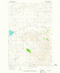
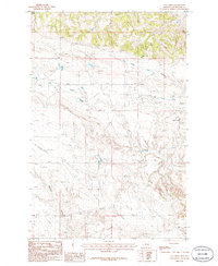
Petrolia Lake serves as a central landmark in this 1963 survey of Petroleum County, where the high plains meet the intricate drainage systems of Flatwillow Creek and Mc Donald Creek. The landscape is defined by its water management and grazing infrastructure, evidenced by the presence of numerous Well sites and the prominent spillway. Settlement patterns in this portion of central Montana are sparse, centered around essential communal and geographic markers such as the Box Elder Sch and the distinct elevation of Rattlesnake Butte. The mapping of fine red dashed lines to indicate selected fence lines provides a rare glimpse into the historical parceling and ranching boundaries of the era. Significant terrain features like Racehorse Coulee and Johnson Coulee slice through the topography, illustrating the erosional character of the region as it transitions between the flat benchlands and the coulee-broken breaks.
Find a feature on this map
11 named features on this map. Tap any name to fly to it.
Don’t see what you’re looking for? This feature index may not catch every label — zoom into the map to look around manually.
Map Details
Editions of this 1963 Petrolia Lake Map
This is the sole edition of this map. No revisions or reprints were ever made.
Other maps of this area

1954 · Roundup
USGS Topo · 1:250,000

1954 · Lewistown
USGS Topo · 1:250,000

1958 · Roundup
USGS Topo · 1:250,000

1959 · Lewistown
USGS Topo · 1:250,000
1963 · Kelley
USGS Topo · 1:24,000
1963 · Breed Spring
USGS Topo · 1:24,000
1963 · Mud Spring
USGS Topo · 1:24,000
1986 · Cat Creek
USGS Topo · 1:24,000
1986 · Ingals Dam
USGS Topo · 1:24,000
1986 · Winnett North
USGS Topo · 1:24,000