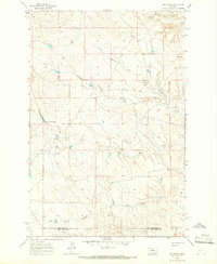
1963 Map of Mud Spring
USGS Topo · Published 1966About this map
Mud Spring and Circle Bar Spring provide critical water sources in this dry landscape at the boundary of Petroleum and Musselshell counties. The area is defined by a dendritic drainage network of intermittent streams, where Maginnis Creek and North Maginnis Creek carve through the terrain. Evidence of water management is visible at a reservoir with a Spillway Elevation of 2996, located near the headwaters of Mud Creek. The geography reveals a ranching landscape reliant on named coulees and springs, such as Salt Sage Coulee and Bar Coulee, which dictate the movement and settlement patterns across these central Montana plains during the early 1960s.
Find a feature on this map
9 named features on this map. Tap any name to fly to it.
Don’t see what you’re looking for? This feature index may not catch every label — zoom into the map to look around manually.
Map Details
Editions of this 1963 Mud Spring Map
This is the sole edition of this map. No revisions or reprints were ever made.
Other maps of this area

1954 · Forsyth
USGS Topo · 1:250,000

1954 · Roundup
USGS Topo · 1:250,000

1957 · Forsyth
USGS Topo · 1:250,000

1958 · Roundup
USGS Topo · 1:250,000

1958 · Forsyth
USGS Topo · 1:250,000

1962 · Mosby
USGS Topo · 1:24,000

1962 · Maxwell Ranch
USGS Topo · 1:24,000

1962 · Melstone NW
USGS Topo · 1:24,000

1963 · Kelley
USGS Topo · 1:24,000

1963 · Petrolia Lake
USGS Topo · 1:24,000