1962 Map of Mosby
USGS Topo · Published 1965About this map
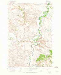
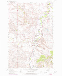
Mosby sits at the northern edge of this landscape where the Musselshell River winds through deep, rhythmic bends in the eastern Montana plains. The topography is defined by the sharp transition between the river bottomlands and the elevated benchlands, which are carved by a series of drainage systems including Flatwillow Creek and the long, wandering course of Shaw Coulee. This 1960s survey captures the region as a sparsely populated ranching and utility corridor, marked by the Petroleum Co Garfield Co boundary line. Resource extraction and water management are evident in features such as the Shaie Reservoir and a Gravel Pit near the riverbanks. The intricate contour lines illustrate a terrain of coulees and breaks, including Anderson Coulee and Bar Circle Coulee, which dictate the placement of roads and the seasonal flow of water toward the river.
Find a feature on this map
15 named features on this map. Tap any name to fly to it.
Don’t see what you’re looking for? This feature index may not catch every label — zoom into the map to look around manually.
Map Details
Editions of this 1962 Mosby Map
2 editions found
Other maps of this area

1954 · Jordan
USGS Topo · 1:250,000

1954 · Forsyth
USGS Topo · 1:250,000

1954 · Roundup
USGS Topo · 1:250,000

1954 · Lewistown
USGS Topo · 1:250,000

1956 · Jordan
USGS Topo · 1:250,000

1957 · Forsyth
USGS Topo · 1:250,000

1958 · Jordan
USGS Topo · 1:250,000

1958 · Roundup
USGS Topo · 1:250,000

1958 · Forsyth
USGS Topo · 1:250,000

1959 · Lewistown
USGS Topo · 1:250,000