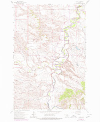
1962 Map of Mosby
USGS Topo · Published 1980About this map
The Musselshell River winds through this central Montana landscape, defining the boundary between Petroleum and Garfield Counties. This region is characterized by deep drainage systems and rugged coulee formations that feed into the river valley. The small settlement of Mosby sits at the northern end of the map, serving as a focal point for the surrounding ranchlands and local infrastructure like the nearby Substation.
Find a feature on this map
11 named features on this map. Tap any name to fly to it.
Don’t see what you’re looking for? This feature index may not catch every label — zoom into the map to look around manually.
Map Details
Editions of this 1962 Mosby Map
2 editions found

Other maps of this area

1954 · Jordan
USGS Topo · 1:250,000

1954 · Forsyth
USGS Topo · 1:250,000

1954 · Roundup
USGS Topo · 1:250,000

1954 · Lewistown
USGS Topo · 1:250,000

1956 · Jordan
USGS Topo · 1:250,000

1957 · Forsyth
USGS Topo · 1:250,000

1958 · Jordan
USGS Topo · 1:250,000

1958 · Roundup
USGS Topo · 1:250,000

1958 · Forsyth
USGS Topo · 1:250,000

1959 · Lewistown
USGS Topo · 1:250,000