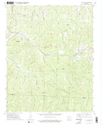
1973 Map of Pettigrew
USGS Topo · Published 1976About this map
The upper reaches of the White River and War Eagle Creek carve through the high elevations of the Ozark National Forest on this 1973 survey of the Arkansas interior. Settlement is concentrated in the small communities of Pettigrew and Dutton, where the terrain briefly levels out along the river valleys. The map is particularly rich in family-named cemetery sites, including Adkins Cem, Dutton Cem, Watson Cem, and Williams Cem, which offer significant data points for genealogists researching the highland residents of Madison and Franklin Counties.
Find a feature on this map
51 named features on this map. Tap any name to fly to it.
Don’t see what you’re looking for? This feature index may not catch every label — zoom into the map to look around manually.
Map Details
Editions of this 1973 Pettigrew Map
2 editions found
Other maps of this area

1879 · Cravens
USGS Topo · 1:62,500

1887 · Watalula
USGS Topo · 1:62,500

1906 · Batson
USGS Topo · 1:62,500

1939 · Watalula
USGS Topo · 1:62,500

1943 · St. Paul
USGS Topo · 1:62,500

1946 · St. Paul
USGS Topo · 1:62,500

1956 · Russellville
USGS Topo · 1:250,000

1964 · Russellville
USGS Topo · 1:250,000
1973 · Witter
USGS Topo · 1:24,000
1973 · Boston
USGS Topo · 1:24,000