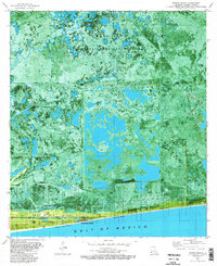
1982 Map of Peveto Beach
USGS Topo · Published 1982About this map
Sabine National Wildlife Refuge dominates the northern expanse of this coastal landscape, where the marshy terrain of Cameron Parish meets the Gulf of Mexico. The map illustrates a complex balance between conservation and the region's energy economy, characterized by the Cameron Meadows Oil and Gas Field and several others networked by pipelines and canals. Along the narrow coastline, residential settlements like Constance Beach and Ocean View Beach sit precariously on the edge of the water, anchored by natural formations like Blue Buck Ridge. This orthophotomap provides a rare visual of the intricate waterways including Old North Bayou and Starks South Canal, which define the movement of water through the wetlands. The presence of a Gas Plant and numerous Drill Hole sites near the shore highlights the industrial footprint on the southwestern Louisiana coast during the early 1980s.
Find a feature on this map
17 named features on this map. Tap any name to fly to it.
Don’t see what you’re looking for? This feature index may not catch every label — zoom into the map to look around manually.
Map Details
Editions of this 1982 Peveto Beach Map
2 editions found
Other maps of this area

1934 · Johnsons Bayou
USGS Topo · 1:24,000

1934 · Holly Beach
USGS Topo · 1:24,000

1934 · Peveto Beach
USGS Topo · 1:24,000

1934 · Greens Bayou
USGS Topo · 1:24,000

1934 · Browns Lake
USGS Topo · 1:24,000

1934 · Five Lakes
USGS Topo · 1:24,000

1935 · Peveto Beach
USGS Topo · 1:31,680

1935 · Five Lakes
USGS Topo · 1:31,680

1935 · Holly Beach
USGS Topo · 1:31,680

1935 · Browns Lake
USGS Topo · 1:31,680