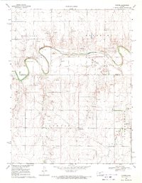
1969 Map of Pfeifer
USGS Topo · Published 1971About this map
Smoky Hill River meanders across the northern portion of this landscape, its sharp oxbows carving through the townships of Wheatland, Freedom, and Illinois. The settlement of Pfeifer sits just south of the river, anchored by the Holy Cross Cem, while further south the map shows Loretta and the St Marys Cem. This 1969 field-checked survey reveals an economy deeply tied to the land's subsurface, marked by numerous Oil Wells and extractive Gravel Pits scattered across the plains. A significant Pipeline traverses the southern half of the quadrangle, cutting across the drainages of Shelter Creek and Duck Creek. The terrain is defined by the transition from the river valley to the breaks of Hungry Hollow, where the surface is etched by field lines and rural road networks connecting isolated homesteads and resource extraction sites.
Find a feature on this map
22 named features on this map. Tap any name to fly to it.
Don’t see what you’re looking for? This feature index may not catch every label — zoom into the map to look around manually.
Map Details
Editions of this 1969 Pfeifer Map
This is the sole edition of this map. No revisions or reprints were ever made.
Other maps of this area

1896 · Hays
USGS Topo · 1:125,000

1955 · Great Bend
USGS Topo · 1:250,000

1957 · Great Bend
USGS Topo · 1:250,000

1958 · Great Bend
USGS Topo · 1:250,000

1961 · Hays South
USGS Topo · 1:24,000
1961 · Walker
USGS Topo · 1:24,000

1961 · Victoria
USGS Topo · 1:24,000
1965 · Otis
USGS Topo · 1:24,000

1966 · La Crosse
USGS Topo · 1:24,000
1966 · Bison
USGS Topo · 1:24,000