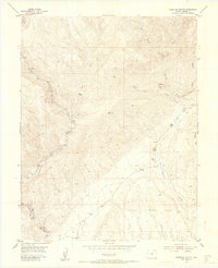
1954 Map of Phantom Canyon
USGS Topo · Published 1955About this map
The rugged terrain of the Colorado Front Range is defined by the steep drainage of Eightmile Creek as it carves through Phantom Canyon. In the mid-1950s, this area of Fremont County remained largely undeveloped, characterized by isolated homesteads and high-elevation landmarks. Local history is centered around the Upper Beaver School and the nearby Upper Beaver Cem situated along Beaver Creek. The map documents a transition from cattle ranching to a more recreation-oriented landscape, with remote outposts like Adelaide, Clark Ranch, and Holbert Cabin serving as lonely markers in the drainages. Geographic features such as Sugar Loaf and the plateau of Table Mountain dominate the skyline, while a Jeep Trail and several pack trails provide the only access through the gulches and canyons. To the south, Soda Springs Park offers a wider valley floor contrasted against the steep canyon walls to the north.
Find a feature on this map
25 named features on this map. Tap any name to fly to it.
Don’t see what you’re looking for? This feature index may not catch every label — zoom into the map to look around manually.
Map Details
Editions of this 1954 Phantom Canyon Map
4 editions found

Other maps of this area

1889 · Canon City
USGS Topo · 1:125,000

1891 · Pueblo
USGS Topo · 1:125,000

1892 · Canon City
USGS Topo · 1:125,000

1893 · Colorado Springs
USGS Topo · 1:125,000

1894 · Pikes Peak
USGS Topo · 1:125,000

1894 · Pueblo
USGS Topo · 1:125,000

1896 · Pueblo
USGS Topo · 1:125,000

1897 · Pueblo
USGS Topo · 1:125,000

1901 · Pikes Peak
USGS Topo · 1:125,000

1909 · Colorado Springs
USGS Topo · 1:125,000