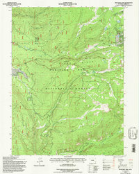
1992 Map of Phantom Lake
USGS Topo · Published 1996About this map
Ryan Park sits at the western edge of this high-elevation terrain within the Medicine Bow National Forest, serving as a focal point for a landscape defined by significant drainage networks and prominent ridgelines. The area is dominated by the massive crests of Medicine Bow Ridge and Slash Ridge, the latter of which is topped by the Slash Ridge Lookout. This 1990s revision reveals a complex system of alpine lakes tucked into the northeastern high country, including Phantom Lake, Arrastre Lake, Magnolia Lake, and Gold Hill Lake. The hydrologic pattern is shaped by the headwaters of numerous streams such as North French Creek and South Brush Creek, which carve through the timbered slopes. Evidence of historic resource management and recreation is visible through the dense network of forest roads and trails that traverse Barrett Ridge and the surrounding basins.
Find a feature on this map
22 named features on this map. Tap any name to fly to it.
Don’t see what you’re looking for? This feature index may not catch every label — zoom into the map to look around manually.
Map Details
Editions of this 1992 Phantom Lake Map
This is the sole edition of this map. No revisions or reprints were ever made.
Other maps of this area

1906 · Medicine Bow
USGS Topo · 1:125,000

1908 · Medicine Bow
USGS Topo · 1:125,000

1939 · Saratoga
USGS Topo · 1:125,000

1954 · Rawlins
USGS Topo · 1:250,000

1958 · Rawlins
USGS Topo · 1:250,000

1961 · Overlook Hill
USGS Topo · 1:24,000

1961 · Ryan Park
USGS Topo · 1:24,000

1961 · Sand Lake
USGS Topo · 1:24,000
1961 · Kennaday Peak
USGS Topo · 1:24,000

1961 · Medicine Bow Peak
USGS Topo · 1:24,000