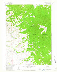
1961 Map of Kennaday Peak
USGS Topo · Published 1963About this map
Kennaday Peak anchors the eastern highlands of this 1960s survey, marking a prominent summit within the Medicine Bow National Forest. The landscape is a complex network of high-altitude water management and ranching operations, where early water rights are evidenced by the Supply Ditch, Wiant Ditch, and Highline Ditch. These systems divert flow from numerous drainages like North Cedar Creek and Sage Brush Creek to support lower elevations.
Find a feature on this map
42 named features on this map. Tap any name to fly to it.
Don’t see what you’re looking for? This feature index may not catch every label — zoom into the map to look around manually.
Map Details
Editions of this 1961 Kennaday Peak Map
3 editions found
Other maps of this area

1893 · Fort Steele
USGS Topo · 1:125,000

1906 · Medicine Bow
USGS Topo · 1:125,000

1908 · Medicine Bow
USGS Topo · 1:125,000

1939 · Saratoga
USGS Topo · 1:125,000

1954 · Rawlins
USGS Topo · 1:250,000

1955 · Elk Mountain SW
USGS Topo · 1:24,000

1955 · Oberg Ranch
USGS Topo · 1:24,000

1955 · Coad Mountain
USGS Topo · 1:24,000

1958 · Rawlins
USGS Topo · 1:250,000

1961 · Ryan Park
USGS Topo · 1:24,000