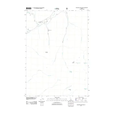
2011 Map of Phi Kappa Mountain
USGS Topo · Published 2011About this map
Phi Kappa Mines stands as a focal point of industrial history in this high-elevation landscape within the Pioneer Mountains. Located along Phi Kappa Creek, the mining site is situated just south of the Phi Kappa Campground, indicating a corridor where early resource extraction and modern recreation intersect. The topography is dominated by massive peaks such as Phi Kappa Mountain, Handwerk Peak, and the uniquely named The Devils Bedstead. This 2011 survey documents a complex drainage network where Summit Creek and Kane Creek collect water from numerous alpine basins. High-altitude water bodies like Kane Lake, Washington Lake, and the Wildhorse Lakes are prominent features, illustrating the glaciated character of the terrain. The map provides a clear record of the access roads and trails that penetrate these steep drainages, supporting both backcountry travel and the study of old mineral claims.
Find a feature on this map
21 named features on this map. Tap any name to fly to it.
Don’t see what you’re looking for? This feature index may not catch every label — zoom into the map to look around manually.
Map Details
Editions of this 2011 Phi Kappa Mountain Map
This is the sole edition of this map. No revisions or reprints were ever made.
Other maps of this area

1895 · Hailey
USGS Topo · 1:125,000

1897 · Hailey
USGS Topo · 1:125,000

1955 · Hailey
USGS Topo · 1:250,000

1959 · Hailey
USGS Topo · 1:250,000

1962 · Hailey
USGS Topo · 1:250,000
1967 · Harry Canyon
USGS Topo · 1:24,000
1967 · Meridian Peak
USGS Topo · 1:24,000

1967 · Rock Roll Canyon
USGS Topo · 1:24,000
1967 · Herd Peak
USGS Topo · 1:24,000

1967 · Sun Valley
USGS Topo · 1:24,000