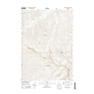
2013 Map of Phi Kappa Mountain
USGS Topo · Published 2013About this map
Challis National Forest and Sawtooth National Forest converge in this high-elevation Idaho landscape, where the administrative boundary between Custer County and Blaine County follows the dramatic ridgelines. The area is defined by massive peaks including The Devils Bedstead and Phi Kappa Mtn, with drainage basins feeding into Phi Kappa Cr and Kane Cr. Evidence of human activity is concentrated at the Phi Kappa Campground and the forest roads 208 and 499. Glacial features are prominent throughout the terrain, represented by high-altitude basins such as those containing Kane Lake, Washington Lake, and the Wildhorse Lakes near Handwerk Peak. The map illustrates the complex drainage patterns of the northern Sawtooth range, tracing the headwaters of Big Fall Cr and Wilson Cr as they descend from Duncan Ridge and Long Gulch.
Find a feature on this map
34 named features on this map. Tap any name to fly to it.
Don’t see what you’re looking for? This feature index may not catch every label — zoom into the map to look around manually.
Map Details
Editions of this 2013 Phi Kappa Mountain Map
This is the sole edition of this map. No revisions or reprints were ever made.
Other maps of this area

1895 · Hailey
USGS Topo · 1:125,000

1897 · Hailey
USGS Topo · 1:125,000

1955 · Hailey
USGS Topo · 1:250,000

1959 · Hailey
USGS Topo · 1:250,000

1962 · Hailey
USGS Topo · 1:250,000
1967 · Harry Canyon
USGS Topo · 1:24,000
1967 · Meridian Peak
USGS Topo · 1:24,000

1967 · Rock Roll Canyon
USGS Topo · 1:24,000
1967 · Herd Peak
USGS Topo · 1:24,000

1967 · Sun Valley
USGS Topo · 1:24,000