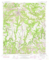
1946 Map of Phil Campbell
USGS Topo · Published 1974About this map
Phil Campbell serves as the primary hub in this postwar landscape, positioned where the Southern railroad corridor cuts through the transition between Franklin and Marion Counties. The map reveals a community deeply tied to both extractive industry and local faith, with numerous small mining operations like the Wilson Mine (Aband) and Benefield Mines scattered among established rural institutions. Educational and spiritual anchors including Phillips High Sch and Bean Creek Ch No 1 provide a clear view of the social geography before modern development shifted these settlement patterns. The winding course of Bear Creek and its many tributaries, such as Little Bear Creek and Turkey Creek, define the topography, while landmarks like Ikes Knob and the Rinehart Wash Hole reflect a deeply local nomenclature of the mid-20th century.
Find a feature on this map
72 named features on this map. Tap any name to fly to it.
Don’t see what you’re looking for? This feature index may not catch every label — zoom into the map to look around manually.
Map Details
Editions of this 1946 Phil Campbell Map
3 editions found

Other maps of this area

1936 · Newburg
USGS Topo · 1:24,000

1936 · Delmar
USGS Topo · 1:24,000

1936 · Kinlock Spring
USGS Topo · 1:24,000

1936 · Isbell
USGS Topo · 1:24,000

1936 · Phil Campbell
USGS Topo · 1:24,000

1936 · South Of Hackleburg
USGS Topo · 1:24,000

1936 · Hackleburg
USGS Topo · 1:24,000

1936 · Spruce Pine
USGS Topo · 1:24,000

1936 · Goddard
USGS Topo · 1:24,000

1945 · Spruce Pine
USGS Topo · 1:24,000