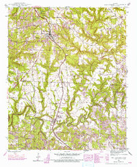
1946 Map of Phil Campbell
USGS Topo · Published 1974About this map
The town of Phil Campbell serves as the focal point of this mid-century landscape, where the Southern railway line and industrial activity intersect with deep-rooted community foundations. The map reveals a transition from agricultural life to extractive industry, noted by the presence of coal operations like the Benefield Mines and Wilson Mine (Aband). Evidence of early twentieth-century rural life is scattered across the terrain in the form of numerous country churches, including Bethel Ch and Mountain View Ch, alongside the Old Union School.
Find a feature on this map
52 named features on this map. Tap any name to fly to it.
Don’t see what you’re looking for? This feature index may not catch every label — zoom into the map to look around manually.
Map Details
Editions of this 1946 Phil Campbell Map
3 editions found

Other maps of this area

1936 · Newburg
USGS Topo · 1:24,000

1936 · Delmar
USGS Topo · 1:24,000

1936 · Kinlock Spring
USGS Topo · 1:24,000

1936 · Isbell
USGS Topo · 1:24,000

1936 · Phil Campbell
USGS Topo · 1:24,000

1936 · South Of Hackleburg
USGS Topo · 1:24,000

1936 · Hackleburg
USGS Topo · 1:24,000

1936 · Spruce Pine
USGS Topo · 1:24,000

1936 · Goddard
USGS Topo · 1:24,000

1945 · Spruce Pine
USGS Topo · 1:24,000