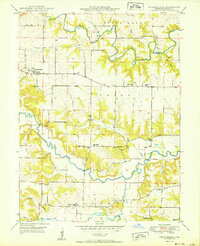
1950 Map of Philadelphia
USGS Topo · Published 1950About this map
Philadelphia serves as a central hub for this rural portion of Marion County, where the winding courses of the South Fabius River and North River dictate the landscape's rhythm. The map reveals a dense network of one-room schoolhouses and community churches that anchored mid-century Missouri life, such as Little Union Ch and the Four Corners Sch. The topography transitions from the high grounds of Round Grove and Pea Ridge down to the creek beds of Pigeon Creek and Keller Branch. Local history is deeply etched into the land through family-named landmarks and small burial grounds like Coleman Cem and Terrell Cem. A specialized rural economy is implied by the dispersed placement of the Schmidt Sch and White Franklin Sch, serving farmsteads scattered across the townships of Union and Warren.
Find a feature on this map
25 named features on this map. Tap any name to fly to it.
Don’t see what you’re looking for? This feature index may not catch every label — zoom into the map to look around manually.
Map Details
Editions of this 1950 Philadelphia Map
2 editions found
Other maps of this area

1903 · Palmyra
USGS Topo · 1:125,000

1948 · Quincy
USGS Topo · 1:250,000

1949 · Durham
USGS Topo · 1:24,000

1949 · Maywood
USGS Topo · 1:24,000

1949 · Palmyra
USGS Topo · 1:24,000

1949 · Philadelphia
USGS Topo · 1:24,000
1950 · Maywood
USGS Topo · 1:24,000

1950 · Durham
USGS Topo · 1:24,000

1950 · Palmyra
USGS Topo · 1:24,000

1950 · Philadelphia
USGS Topo · 1:24,000