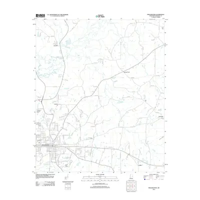
2012 Map of Philadelphia
USGS Topo · Published 2012About this map
Philadelphia serves as the focal point of this Neshoba County landscape, where the urban street grid meets the winding tributaries of the Pearl River. The town's growth is marked by its aviation infrastructure at Philadelphia Municipal Airport and Barrett Field Airport, while its historical depth is preserved in numerous burial grounds such as Cedarlawn Cem and Philadelphia Cem. To the north and east, the landscape transitions into a network of rural communities and crossroads settlements, including Burnside, Longino, and Sandtown. Drainage patterns are defined by the Bogue Kentawka south of the city and the serpentine path of Ocobla Cr to the southeast. This survey details the intersection of modern municipal development with the traditional rural hamlets that have long defined the region's geography.
Find a feature on this map
141 named features on this map. Tap any name to fly to it.
Don’t see what you’re looking for? This feature index may not catch every label — zoom into the map to look around manually.
Map Details
Editions of this 2012 Philadelphia Map
This is the sole edition of this map. No revisions or reprints were ever made.
Other maps of this area

1953 · Meridian
USGS Topo · 1:250,000

1957 · Meridian
USGS Topo · 1:250,000

1962 · House
USGS Topo · 1:24,000

1962 · Vernon
USGS Topo · 1:24,000

1962 · Owl Creek
USGS Topo · 1:24,000

1965 · Meridian
USGS Topo · 1:250,000

1972 · Pearl River
USGS Topo · 1:24,000

1972 · Plattsburg
USGS Topo · 1:24,000
1972 · Noxapater
USGS Topo · 1:24,000

1972 · Deemer
USGS Topo · 1:24,000