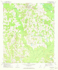
1972 Map of Noxapater
USGS Topo · Published 1973About this map
Noxapater stands at the center of this rural landscape where the Gulf Mobile and Ohio railroad cuts through the heavy timber and undulating terrain of Winston County. The town's grid is shadowed by the winding course of Noxapater Creek, which flows southwest toward the Neshoba County line. The map reveals a deeply rooted rural community defined by its spiritual geography, featuring numerous local congregations such as Mt Vernon Ch, Union Ridge Ch, and Mt Ary Ch.
Find a feature on this map
26 named features on this map. Tap any name to fly to it.
Don’t see what you’re looking for? This feature index may not catch every label — zoom into the map to look around manually.
Map Details
Editions of this 1972 Noxapater Map
This is the sole edition of this map. No revisions or reprints were ever made.
Other maps of this area

1953 · Meridian
USGS Topo · 1:250,000

1953 · West Point
USGS Topo · 1:250,000

1957 · Meridian
USGS Topo · 1:250,000

1958 · West Point
USGS Topo · 1:250,000

1962 · Vernon
USGS Topo · 1:24,000

1962 · Owl Creek
USGS Topo · 1:24,000

1963 · West Point
USGS Topo · 1:250,000

1965 · Meridian
USGS Topo · 1:250,000

1972 · Pearl River
USGS Topo · 1:24,000

1972 · Plattsburg
USGS Topo · 1:24,000