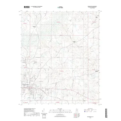
2018 Map of Philadelphia
USGS Topo · Published 2018About this map
Philadelphia serves as the central hub of this Neshoba County landscape, where the urban grid of the county seat meets the winding waterways of central Mississippi. The terrain is defined by the headwaters of the Pearl River and its numerous tributaries, including Hurricane Cr and Ocobla Cr. Small rural settlements like Burnside to the north and Sandtown to the east are connected by a network of county roads, reflecting a long-standing pattern of dispersed agricultural communities. Genealogists will find significant detail in the various burial grounds and houses of worship scattered across the townships, such as Hopewell Cem and Spring Creek Ch. Near the city, the presence of the Philadelphia Municipal Airport and Barrett Field highlights the area's modern infrastructure, while the marshy lowlands of the Bogue Kentawka suggest the persistent influence of the natural river system on local development.
Find a feature on this map
137 named features on this map. Tap any name to fly to it.
Don’t see what you’re looking for? This feature index may not catch every label — zoom into the map to look around manually.
Map Details
Editions of this 2018 Philadelphia Map
This is the sole edition of this map. No revisions or reprints were ever made.
Other maps of this area

1953 · Meridian
USGS Topo · 1:250,000

1957 · Meridian
USGS Topo · 1:250,000

1962 · House
USGS Topo · 1:24,000

1962 · Vernon
USGS Topo · 1:24,000

1962 · Owl Creek
USGS Topo · 1:24,000

1965 · Meridian
USGS Topo · 1:250,000

1972 · Pearl River
USGS Topo · 1:24,000

1972 · Plattsburg
USGS Topo · 1:24,000
1972 · Noxapater
USGS Topo · 1:24,000

1972 · Deemer
USGS Topo · 1:24,000