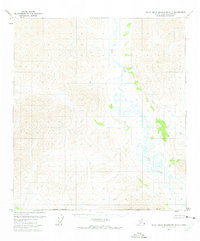
1971 Map of Philip Smith Mountains A-1
USGS Topo · Published 1975About this map
The Wind River carves a path through this remote portion of the North Slope, documented here through 1970 aerial photography. The landscape is defined by its drainages and the South Boundary Umiat Meridian, representing a vast area of unsurveyed wilderness under the jurisdiction of the Bureau of Land Management. This 1971 study reveals a terrain of low-relief wetlands and swamps concentrated along the river corridor, highlighting the hydrologic patterns of the Arctic interior before significant modern development. The inclusion of the Borough Boundary provides a jurisdictional context for this uninhabited expanse, where the natural course of the water remains the primary geographical landmark.
Find a feature on this map
3 named features on this map. Tap any name to fly to it.
Don’t see what you’re looking for? This feature index may not catch every label — zoom into the map to look around manually.
Map Details
Editions of this 1971 Philip Smith Mountains A-1 Map
2 editions found
Other maps of this area

1951 · Chandalar
USGS Topo · 1:250,000

1951 · Christian
USGS Topo · 1:250,000

1951 · Brooks
USGS Topo · 1:250,000

1951 · Arctic
USGS Topo · 1:250,000

1956 · Arctic
USGS Topo · 1:250,000

1956 · Chandalar
USGS Topo · 1:250,000

1956 · Philip Smith Mountains
USGS Topo · 1:250,000

1956 · Christian
USGS Topo · 1:250,000

1964 · Chandalar
USGS Topo · 1:250,000

1964 · Philip Smith Mountains
USGS Topo · 1:250,000