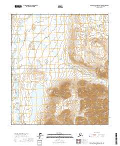
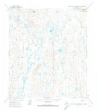
2017 Map of Philip Smith Mountains B-5 NW
USGS Topo · Published 2017About this map
Gates of the Arctic National Preserve dominates the southeastern quadrant of this map, marking a transition from the lower elevations of the Itkillik River valley to more dramatic mountain terrain. The presence of Itkillik Lake provides a central focal point, serving as a primary drainage basin for the surrounding slopes. The river system, including the Itkmalak River, illustrates a classic Arctic hydrological pattern where braided channels navigate through broad glacial valleys. Further north, Victor Gulch and the Oolah Valley demonstrate how the local topography is carved by seasonal runoff and ancient glacial activity, creating a landscape largely shaped by water and ice in the North Slope Borough.
Find a feature on this map
10 named features on this map. Tap any name to fly to it.
Don’t see what you’re looking for? This feature index may not catch every label — zoom into the map to look around manually.
Map Details
Editions of this 2017 Philip Smith Mountains B-5 NW Map
This is the sole edition of this map. No revisions or reprints were ever made.
Other maps of this area

1951 · Chandler Lake
USGS Topo · 1:250,000

1951 · Brooks
USGS Topo · 1:250,000

1956 · Philip Smith Mountains
USGS Topo · 1:250,000

1956 · Chandler Lake
USGS Topo · 1:250,000

1964 · Philip Smith Mountains
USGS Topo · 1:250,000

1964 · Chandler Lake
USGS Topo · 1:250,000
1971 · Chandler Lake C-1
USGS Topo · 1:63,360
1971 · Philip Smith Mountains B-5
USGS Topo · 1:63,360
1971 · Chandler Lake B-1
USGS Topo · 1:63,360
1971 · Philip Smith Mountains C-5
USGS Topo · 1:63,360