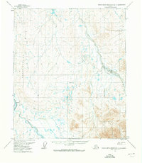
1971 Map of Philip Smith Mountains D-3
USGS Topo · Published 1973About this map
Oksrukuyik serves as a notable landmark in this 1970s landscape, positioned near the bank of the Sagavanirktok River. This remote Arctic territory is defined by its vast drainage systems, where the Lupine River and Ribdon River carve through the terrain. The presence of a Winter Rd running parallel to the primary river system highlights the seasonal transportation methods essential for navigating this northern environment before more permanent infrastructure arrived. Physical features such as the Kakuktukruich mountains and the prominent Bluff provide distinct topographical markers in an otherwise transition-heavy landscape. The mapping, based on 1970 aerial photography, captures the drainage patterns and early overland routes prior to significant industrial expansion in the North Slope region.
Find a feature on this map
7 named features on this map. Tap any name to fly to it.
Don’t see what you’re looking for? This feature index may not catch every label — zoom into the map to look around manually.
Map Details
Editions of this 1971 Philip Smith Mountains D-3 Map
This is the sole edition of this map. No revisions or reprints were ever made.
Other maps of this area

1951 · Sagavanirktok D-5
USGS Topo · 1:250,000

1951 · Brooks
USGS Topo · 1:250,000

1956 · Philip Smith Mountains
USGS Topo · 1:250,000

1956 · Sagavanirktok
USGS Topo · 1:250,000

1958 · Sagavanirktok
USGS Topo · 1:250,000

1964 · Philip Smith Mountains
USGS Topo · 1:250,000

1964 · Sagavanirktok
USGS Topo · 1:250,000

1971 · Philip Smith Mountains C-4
USGS Topo · 1:63,360
1971 · Philip Smith Mountains C-2
USGS Topo · 1:63,360
1971 · Philip Smith Mountains D-2
USGS Topo · 1:63,360