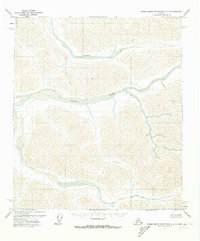
1971 Map of Philip Smith Mountains C-2
USGS Topo · Published 1973About this map
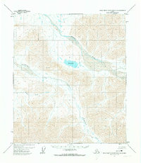
Ribdon River and the Lupine River dominate this 1971 study of the North Slope's interior. This topographical record illustrates a landscape defined by braided river systems and steep elevation changes, mapped via photogrammetry from 1970 aerial photography. The Lupine River flows across the northern section of the quadrangle, while the Ribdon River carves a path through the central region, both showcasing the characteristic alluvial patterns of the Brooks Range foothills. Based on control from the USGS and USC&GS, the map represents a wilderness area that remained largely unsurveyed on the ground, with land lines pre-determined by the Bureau of Land Management but not yet marked in the field at the time of publication.
Find a feature on this map
2 named features on this map. Tap any name to fly to it.
Don’t see what you’re looking for? This feature index may not catch every label — zoom into the map to look around manually.
Map Details
Editions of this 1971 Philip Smith Mountains C-2 Map
This is the sole edition of this map. No revisions or reprints were ever made.
Other maps of this area

1951 · Brooks
USGS Topo · 1:250,000

1956 · Philip Smith Mountains
USGS Topo · 1:250,000

1964 · Philip Smith Mountains
USGS Topo · 1:250,000
1971 · Philip Smith Mountains D-3
USGS Topo · 1:63,360
1971 · Philip Smith Mountains C-1
USGS Topo · 1:63,360
1971 · Philip Smith Mountains D-2
USGS Topo · 1:63,360
1971 · Philip Smith Mountains C-3
USGS Topo · 1:63,360

1971 · Philip Smith Mountains B-1
USGS Topo · 1:63,360

1971 · Philip Smith Mountains B-3
USGS Topo · 1:63,360
1971 · Philip Smith Mountains D-1
USGS Topo · 1:63,360