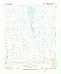
1971 Map of Philip Smith Mountains D-5
USGS Topo · Published 1974About this map
Kuparuk River flows northward through a broad, braided drainage system at the heart of this North Slope survey, reflecting the hydrologic patterns of the Arctic landscape in the early 1970s. The terrain is characterized by expansive wetlands and low-relief marshy areas, interpreted by Usgs cartographers from 1970 aerial photography. While much of the quadrangle is defined by these water-saturated plains, higher elevations are marked by distinctive landmarks like Aruk and the prominent Imnavait Mountain in the southeast. Along the western edge, the Itkillik River winds through the tundra, illustrating the complex network of waterways that define this remote region of the Umiat Meridian. This map provides a technical record of the surface topography before significant modern infrastructure altered the area, capturing the natural state of the Alaskan interior's drainage basins and landform features.
Find a feature on this map
4 named features on this map. Tap any name to fly to it.
Don’t see what you’re looking for? This feature index may not catch every label — zoom into the map to look around manually.
Map Details
Editions of this 1971 Philip Smith Mountains D-5 Map
This is the sole edition of this map. No revisions or reprints were ever made.
Other maps of this area

1951 · Sagavanirktok D-5
USGS Topo · 1:250,000

1951 · Chandler Lake
USGS Topo · 1:250,000

1951 · Brooks
USGS Topo · 1:250,000

1952 · Umiat
USGS Topo · 1:250,000

1956 · Philip Smith Mountains
USGS Topo · 1:250,000

1956 · Chandler Lake
USGS Topo · 1:250,000

1956 · Sagavanirktok
USGS Topo · 1:250,000

1956 · Umiat
USGS Topo · 1:250,000

1958 · Sagavanirktok
USGS Topo · 1:250,000

1964 · Philip Smith Mountains
USGS Topo · 1:250,000