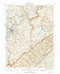
1939 Map of Philipsburg
USGS Topo · Published 1964About this map
Philipsburg sits at the heart of this landscape, where the Moshannon Creek carves a winding path through the plateau. During the late 1930s, the region was defined by a complex network of resource extraction and transit, evidenced by the New York Central and Pennsylvania railroads serving coal operations like the Rusnak Mine and Cuba Mine. The map shows a transition from the industrial valley floors to the high timberlands of the Black Moshannon State Park and Allegheny Mountain. Rural life is meticulously documented through numerous small schoolhouses such as Henderson Sch and Bell Hollow Sch, alongside landmarks of early iron production like Martha Furnace. The mapping reveals how topography dictated settlement, with towns like Winburne and Kylertown clustered near water and rail, while the high ridges remained the domain of fire towers and state game lands.
Find a feature on this map
95 named features on this map. Tap any name to fly to it.
Don’t see what you’re looking for? This feature index may not catch every label — zoom into the map to look around manually.
Map Details
Editions of this 1939 Philipsburg Map
2 editions found

Other maps of this area

1903 · Houtzdale
USGS Topo · 1:62,500

1905 · Houtzdale
USGS Topo · 1:62,500

1908 · Bellefonte
USGS Topo · 1:62,500

1909 · Bellefonte
USGS Topo · 1:62,500

1919 · Menno
USGS Topo · 1:62,500

1920 · Altoona
USGS Topo · 1:62,500

1922 · Philipsburg
USGS Topo · 1:62,500

1922 · Altoona
USGS Topo · 1:62,500

1923 · Tyrone
USGS Topo · 1:62,500

1928 · Snow Shoe
USGS Topo · 1:48,000