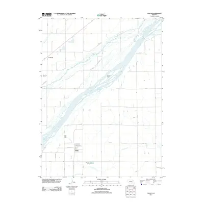
2011 Map of Phillips
USGS Topo · Published 2011About this map
Phillips and the nearby siding of Lockwood define the agricultural landscape of Hamilton County in the early 21st century. The village of Phillips serves as a local hub, anchored by the Phillips Post Office and connected to the wider region by the Burlington Northern Santa Fe rail line. This area is characterized by the complex hydrology of the Platte River valley, where the main channel weaves around Guendel Island. Parallel watercourses including the Wood River, Warm Slough, and Lincoln Creek drain the surrounding plains, which are meticulously divided by a grid of rural roads such as Fort Kearney Rd and Vieregg Rd. To the south, the Edgerton Dam creates the Edgerton Reservoir, a notable water management feature in this prairie environment. The presence of the Terry Farm Airport reflects the continued importance of private aviation in supporting the local farming economy.
Find a feature on this map
45 named features on this map. Tap any name to fly to it.
Don’t see what you’re looking for? This feature index may not catch every label — zoom into the map to look around manually.
Map Details
Editions of this 2011 Phillips Map
This is the sole edition of this map. No revisions or reprints were ever made.
Other maps of this area

1892 · Grand Island
USGS Topo · 1:62,500

1895 · Grand Island
USGS Topo · 1:62,500

1898 · Grand Island
USGS Topo · 1:125,000

1899 · St. Paul
USGS Topo · 1:125,000

1955 · Broken Bow
USGS Topo · 1:250,000

1955 · Grand Island
USGS Topo · 1:250,000

1956 · Broken Bow
USGS Topo · 1:250,000

1957 · Grand Island
USGS Topo · 1:250,000

1958 · Grand Island
USGS Topo · 1:250,000
1961 · St. Libory
USGS Topo · 1:24,000