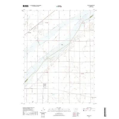
2017 Map of Phillips
USGS Topo · Published 2017About this map
The Platte River corridor dominates this central Nebraska landscape, defining the boundary between Merrick and Hamilton counties. The braided river system surrounds Guendel Island and is paralleled to the north by the Wood River and the ephemeral Warm Slough. The rural settlement pattern is anchored by the village of Phillips in the south and the small community of Lockwood to the northwest. This 2017 survey reveals the persistent grid of section-line roads, such as Ft Kearney and Vieregg RD, that navigate the flat river bottomlands. Water management is a visible priority across the terrain, evidenced by the Edgerton Reservoir and the winding course of Lincoln Cr. For those researching local history, the Phillips Cem serves as a critical genealogical anchor for the families who settled this agricultural region along the river valley.
Find a feature on this map
55 named features on this map. Tap any name to fly to it.
Don’t see what you’re looking for? This feature index may not catch every label — zoom into the map to look around manually.
Map Details
Editions of this 2017 Phillips Map
This is the sole edition of this map. No revisions or reprints were ever made.
Other maps of this area

1892 · Grand Island
USGS Topo · 1:62,500

1895 · Grand Island
USGS Topo · 1:62,500

1898 · Grand Island
USGS Topo · 1:125,000

1899 · St. Paul
USGS Topo · 1:125,000

1955 · Broken Bow
USGS Topo · 1:250,000

1955 · Grand Island
USGS Topo · 1:250,000

1956 · Broken Bow
USGS Topo · 1:250,000

1957 · Grand Island
USGS Topo · 1:250,000

1958 · Grand Island
USGS Topo · 1:250,000
1961 · St. Libory
USGS Topo · 1:24,000