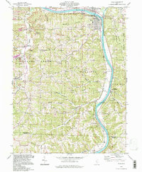
1994 Map of Philo
USGS Topo · Published 1998About this map
The Muskingum River dominates the eastern half of this landscape, carving a deep valley through the hills of Muskingum Co and Morgan Co. The twin settlements of Duncan Falls and Philo anchor the northern reach, where the Muskingum River Parkway State Park preserves the river's edge. Beyond the river corridor, the terrain rises into a series of prominent ridges such as Fatler Ridge, Butterbean Ridge, and Poverty Ridge, which are defined by a network of runs and hollows. The presence of numerous strip mines in the northwest around Cannelville and Stovertown points to the area's coal mining history.
Find a feature on this map
65 named features on this map. Tap any name to fly to it.
Don’t see what you’re looking for? This feature index may not catch every label — zoom into the map to look around manually.
Map Details
Editions of this 1994 Philo Map
This is the sole edition of this map. No revisions or reprints were ever made.
Other maps of this area

1910 · Philo
USGS Topo · 1:62,500

1910 · Zanesville
USGS Topo · 1:62,500

1910 · Mc Connelsville
USGS Topo · 1:62,500

1911 · New Lexington
USGS Topo · 1:62,500

1947 · Columbus
USGS Topo · 1:250,000

1949 · Clarksburg
USGS Topo · 1:250,000

1956 · Clarksburg
USGS Topo · 1:250,000

1961 · Columbus
USGS Topo · 1:250,000

1961 · Clarksburg
USGS Topo · 1:250,000

1961 · Mc Connelsville
USGS Topo · 1:24,000