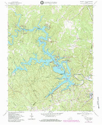
1967 Map of Philpott Lake
USGS Topo · Published 1984About this map
Philpott Lake dominates this 1967 survey, its intricate shoreline stretching across the borders of Franklin, Henry, and Patrick counties. Formed by the Philpott Dam on the Smith River, the reservoir created a complex network of points and islands including Horseshoe Point, Goose Point, and Turkey Island. The map illustrates the region's transition into a major recreational hub during the mid-20th century, with numerous facilities such as the Ryans Branch Rec Area and the expansive Fairy Stone State Park flanking the western waters.
Find a feature on this map
71 named features on this map. Tap any name to fly to it.
Don’t see what you’re looking for? This feature index may not catch every label — zoom into the map to look around manually.
Map Details
Editions of this 1967 Philpott Lake Map
Other maps of this area

1924 · Martinsville
USGS Topo · 1:48,000

1925 · Rocky Mount
USGS Topo · 1:48,000

1926 · Martinsville
USGS Topo · 1:62,500

1926 · Critz
USGS Topo · 1:48,000

1927 · Rocky Mount
USGS Topo · 1:62,500

1927 · Martinsville
USGS Topo · 1:62,500

1928 · Critz
USGS Topo · 1:62,500

1944 · Martinsville
USGS Topo · 1:62,500

1944 · Rocky Mount
USGS Topo · 1:62,500

1953 · Winston-Salem
USGS Topo · 1:250,000