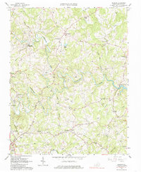
1963 Map of Redwood
USGS Topo · Published 1985About this map
Maggodee Creek and the Blackwater River snake through this central Franklin County landscape, shaping a rural environment defined by family names and small-scale industry. The presence of the Piedmont Mill and Powder Mill Creek suggests an economy rooted in water-powered operations, while the Norfolk and Western Railroad Grade cuts across the southern portion of the sheet near Redwood. This era of the early 1960s captures the region as Smith Mountain Lake was being established, with its controlled inundation line noted in the east. Local life is densely documented through numerous family burial sites such as the Poindexter and Chitwood cemeteries, alongside social hubs like the Drive-in Theater near Franklin Heights. Settlements like Burnt Chimney and Taylors Store anchor the crossroads of this Piedmont community before modern development altered the rural character.
Find a feature on this map
52 named features on this map. Tap any name to fly to it.
Don’t see what you’re looking for? This feature index may not catch every label — zoom into the map to look around manually.
Map Details
Editions of this 1963 Redwood Map
4 editions found
Other maps of this area

1890 · Roanoke
USGS Topo · 1:125,000

1891 · Roanoke
USGS Topo · 1:125,000

1922 · Callands
USGS Topo · 1:48,000

1924 · Callands
USGS Topo · 1:62,500

1925 · Rocky Mount
USGS Topo · 1:48,000

1927 · Rocky Mount
USGS Topo · 1:62,500

1944 · Rocky Mount
USGS Topo · 1:62,500

1944 · Callands
USGS Topo · 1:62,500

1947 · Roanoke
USGS Topo · 1:250,000

1951 · Boones Mill
USGS Topo · 1:62,500