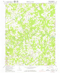
1963 Map of Redwood
USGS Topo · Published 1979About this map
Blackwater River and Maggodee Creek define the drainage of this rural landscape in the mid-1960s, prior to the major flooding of the region by Smith Mountain Lake. The settlement pattern reflects a deeply rooted agrarian society, where small crossroads like Burnt Chimney and Redwood serve as local hubs for scattered farmsteads. Genealogical interest is particularly high here, as the map documents dozens of family burial grounds, including the Poindexter, Altice, and McGuire cemeteries, which are often the only remaining markers of nineteenth-century homesteads. Industrial history is represented by the Piedmont Mill and the Norfolk and Western rail line, which cuts through the southwestern corner near Rocky Mount. An Old Railroad Grade running through the center of the sheet indicates a shift in local transport and commerce even by the time of this survey.
Find a feature on this map
60 named features on this map. Tap any name to fly to it.
Don’t see what you’re looking for? This feature index may not catch every label — zoom into the map to look around manually.
Map Details
Editions of this 1963 Redwood Map
4 editions found
Other maps of this area

1890 · Roanoke
USGS Topo · 1:125,000

1891 · Roanoke
USGS Topo · 1:125,000

1922 · Callands
USGS Topo · 1:48,000

1924 · Callands
USGS Topo · 1:62,500

1925 · Rocky Mount
USGS Topo · 1:48,000

1927 · Rocky Mount
USGS Topo · 1:62,500

1944 · Rocky Mount
USGS Topo · 1:62,500

1944 · Callands
USGS Topo · 1:62,500

1947 · Roanoke
USGS Topo · 1:250,000

1951 · Boones Mill
USGS Topo · 1:62,500