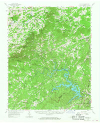
1957 Map of Endicott
USGS Topo · Published 1968About this map
Fairy Stone State Park and the sprawling waters behind Philpott Dam dominate the southern portion of this landscape, where the Smith River is impounded to form a complex of inlets and islands including Goose Pt and Turkey Island. To the north, the terrain rises toward the Blue Ridge Parkway, which skirts the western edge near Smart View Park. The area is characterized by a dense network of mountain communities and remote schools such as the Phoebe Needles Memorial Sch and Ferrum Jr College.
Find a feature on this map
99 named features on this map. Tap any name to fly to it.
Don’t see what you’re looking for? This feature index may not catch every label — zoom into the map to look around manually.
Map Details
Editions of this 1957 Endicott Map
2 editions found

Other maps of this area

1890 · Roanoke
USGS Topo · 1:125,000

1890 · Christiansburg
USGS Topo · 1:125,000

1891 · Roanoke
USGS Topo · 1:125,000

1924 · Martinsville
USGS Topo · 1:48,000

1925 · Rocky Mount
USGS Topo · 1:48,000

1926 · Martinsville
USGS Topo · 1:62,500

1926 · Critz
USGS Topo · 1:48,000

1927 · Rocky Mount
USGS Topo · 1:62,500

1927 · Martinsville
USGS Topo · 1:62,500

1928 · Stuart
USGS Topo · 1:48,000