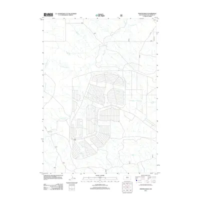
2012 Map of Phister Ranch
USGS Topo · Published 2012About this map
Phister Ranch serves as the namesake landmark for this ranching landscape in Fall River County, where the high plains of South Dakota are carved by an intricate network of seasonal drainages. The area is defined by the winding course of Cottonwood Cr and its various tributaries, including Little Cottonwood Cr and Softwater Cr, which dictate the local topography and the placement of rural access roads like Co Hwy 8. The map reveals a distinct pattern of land use, with several large, geometrically subdivided plots that stand out against the natural contours of Buck Draw and Alum Cr. These surveyed divisions, many connected by graded routes such as Rd 7007, suggest specialized agricultural or grazing developments typical of the modern western ranching economy.
Find a feature on this map
10 named features on this map. Tap any name to fly to it.
Don’t see what you’re looking for? This feature index may not catch every label — zoom into the map to look around manually.
Map Details
Editions of this 2012 Phister Ranch Map
This is the sole edition of this map. No revisions or reprints were ever made.
Other maps of this area

1902 · Edgemont
USGS Topo · 1:125,000

1950 · Edgemont
USGS Topo · 1:24,000

1950 · Edgemont SW
USGS Topo · 1:24,000

1955 · Hot Springs
USGS Topo · 1:250,000

1955 · Newcastle
USGS Topo · 1:250,000

1958 · Newcastle
USGS Topo · 1:250,000

1978 · Coffee Flats
USGS Topo · 1:24,000
1978 · Oat Creek
USGS Topo · 1:24,000
1978 · Mule Creek SE
USGS Topo · 1:24,000

1981 · Lance Creek
USGS Topo · 1:100,000