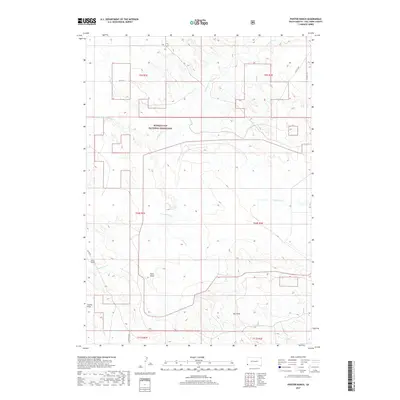
2017 Map of Phister Ranch
USGS Topo · Published 2017About this map
Buffalo Gap National Grassland dominates the landscape of this corner of Fall River County, where the high plains of South Dakota transition into a network of dry draws and seasonal drainages. Ranching life is etched into the topography through namesake features like Phister Ranch and Wallace Ranch, reflecting the enduring agricultural heritage of the region. The map reveals a land defined by water management in a semi-arid environment, notable in the presence of Crowe Dam and the sprawling Coffee Flats. Significant natural drainages including Cottonwood Cr, Alum Cr, and Softwater Cr carve through the terrain, while topographical depressions such as Buck Draw, Hay Draw, and Coyote Draw provide a detailed look at the local geomorphology. This 2017 survey shows how modern infrastructure like CO Hwy 8 and various township roads interface with the vast public lands and private ranch holdings of the Black Hills foothills.
Find a feature on this map
22 named features on this map. Tap any name to fly to it.
Don’t see what you’re looking for? This feature index may not catch every label — zoom into the map to look around manually.
Map Details
Editions of this 2017 Phister Ranch Map
This is the sole edition of this map. No revisions or reprints were ever made.
Other maps of this area

1902 · Edgemont
USGS Topo · 1:125,000

1950 · Edgemont
USGS Topo · 1:24,000

1950 · Edgemont SW
USGS Topo · 1:24,000

1955 · Hot Springs
USGS Topo · 1:250,000

1955 · Newcastle
USGS Topo · 1:250,000

1958 · Newcastle
USGS Topo · 1:250,000

1978 · Coffee Flats
USGS Topo · 1:24,000
1978 · Oat Creek
USGS Topo · 1:24,000
1978 · Mule Creek SE
USGS Topo · 1:24,000

1981 · Lance Creek
USGS Topo · 1:100,000