
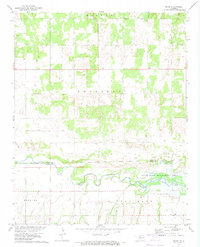
1969 Map of Phroso
USGS Topo · Published 1971About this map
The small settlement of Phroso anchors this late-1960s landscape, situated in a region defined by agricultural land and increasing energy extraction. Mapping indicates an active industrial footprint across the terrain, notably at the Jones Oil Field and the numerous Gas Wells and Oil Wells peppered throughout the sections. Local genealogy is well-preserved through the marking of several burial grounds, including Mt Zion Cem, Antioch Cem, and Golden Lodge Cem.
Find a feature on this map
15 named features on this map. Tap any name to fly to it.
Don’t see what you’re looking for? This feature index may not catch every label — zoom into the map to look around manually.
Map Details
Editions of this 1969 Phroso Map
This is the sole edition of this map. No revisions or reprints were ever made.
Other maps of this area

1955 · Woodward
USGS Topo · 1:250,000

1958 · Woodward
USGS Topo · 1:250,000

1969 · Belva
USGS Topo · 1:24,000

1969 · Glass Mountains NW
USGS Topo · 1:24,000

1969 · Cedardale
USGS Topo · 1:24,000

1969 · Togo
USGS Topo · 1:24,000

1969 · Glass Mountains SW
USGS Topo · 1:24,000

1972 · Canton NW
USGS Topo · 1:24,000

1972 · Seiling
USGS Topo · 1:24,000
1972 · Orion
USGS Topo · 1:24,000