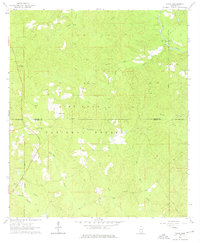
1964 Map of Piave
USGS Topo · Published 1976About this map
De Soto National Forest dominates this mid-century landscape across the Wayne and Greene County line. The topography is defined by a dense network of watercourses, including the central Cary Creek and the strikingly named Hell Hole near Hell Hole Creek. Cultural landmarks are sparse but significant for local history, with Smithtown and Piave serving as the primary settlements. The presence of Piney Woods Lookout Tower and Stony Lookout Tower underscores the region's reliance on forest management and timber resources during this era. Genealogists will find value in the specific locations of Henderson Cem and rural spiritual centers such as Bethel Ch and West Salem Ch, which served these timber-reliant communities. The map also documents fine details like fence and field lines, reflecting the small-scale agricultural clearings carved out of the surrounding woodlands.
Find a feature on this map
25 named features on this map. Tap any name to fly to it.
Don’t see what you’re looking for? This feature index may not catch every label — zoom into the map to look around manually.
Map Details
Editions of this 1964 Piave Map
4 editions found
Other maps of this area

1953 · Hattiesburg
USGS Topo · 1:250,000

1958 · Hattiesburg
USGS Topo · 1:250,000

1963 · Brewer
USGS Topo · 1:24,000

1964 · Knobtown
USGS Topo · 1:24,000

1964 · Clark
USGS Topo · 1:24,000

1964 · Clara
USGS Topo · 1:24,000

1964 · Mulberry
USGS Topo · 1:24,000

1964 · Buckatunna
USGS Topo · 1:24,000

1964 · Avera
USGS Topo · 1:24,000

1964 · Piave
USGS Topo · 1:24,000