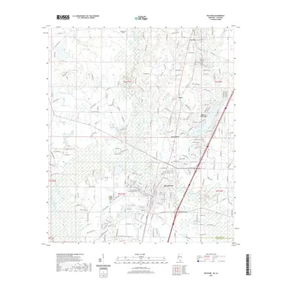
2020 Map of Picayune
USGS Topo · Published 2020About this map
The city of Picayune serves as the primary anchor for this portion of Pearl River County, where the convergence of East Hobolochitto Creek and West Hobolochitto Creek shapes the local drainage and topography. The map illustrates a landscape transitioning from the urban grid of the city center to residential developments and the planned community around Hide-A-Way Lake. To the north, the smaller settlements of Carriere and Richardson sit along the transportation corridor, while the George Ford Airport and the Pearl River County Governmental Complex mark points of regional infrastructure. Local history is anchored by the Pearl River Cem and numerous named branches such as Alligator Br and Second Alligator Br. The detailed street names, from Dumas Bailey Rd to Hickory Nut Rd, provide a modern record of land divisions and access routes throughout this Mississippi-Louisiana border region.
Find a feature on this map
220 named features on this map. Tap any name to fly to it.
Don’t see what you’re looking for? This feature index may not catch every label — zoom into the map to look around manually.
Map Details
Editions of this 2020 Picayune Map
This is the sole edition of this map. No revisions or reprints were ever made.
Other maps of this area

1914 · Nicholson
USGS Topo · 1:62,500

1921 · Nicholson
USGS Topo · 1:62,500

1935 · Slidell
USGS Topo · 1:62,500

1939 · Slidell
USGS Topo · 1:62,500

1941 · Honey Island
USGS Topo · 1:31,680

1942 · Walkiah Bluff
USGS Topo · 1:31,680

1942 · Pools Bluff
USGS Topo · 1:31,680

1950 · Slidell
USGS Topo · 1:62,500

1953 · Mobile
USGS Topo · 1:250,000

1955 · Nicholson
USGS Topo · 1:24,000