
1958 Map of Picayune
USGS Topo · Published 1959About this map
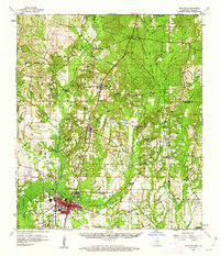
Picayune serves as the focal point of this late 1950s survey, situated along the Southern railroad line in the southwestern corner of the quadrangle. The settlement pattern is defined by small clusters and rural crossroads that follow the rail corridor and the various branches of Hobolochitto Creek. To the north and east, the landscape is characterized by numerous family-named landmarks and rural institutions, including Sones Chapel, West Union Ch, and the Lee Sch.
Find a feature on this map
68 named features on this map. Tap any name to fly to it.
Don’t see what you’re looking for? This feature index may not catch every label — zoom into the map to look around manually.
Map Details
Editions of this 1958 Picayune Map
2 editions found
Other maps of this area

1914 · Nicholson
USGS Topo · 1:62,500

1921 · Nicholson
USGS Topo · 1:62,500

1935 · Slidell
USGS Topo · 1:62,500

1939 · Slidell
USGS Topo · 1:62,500

1941 · Honey Island
USGS Topo · 1:31,680

1942 · Walkiah Bluff
USGS Topo · 1:31,680

1942 · Pools Bluff
USGS Topo · 1:31,680

1949 · Bogalusa East
USGS Topo · 1:31,680

1950 · Slidell
USGS Topo · 1:62,500

1953 · Mobile
USGS Topo · 1:250,000