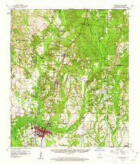
1958 Map of Picayune
USGS Topo · Published 1962About this map
Picayune serves as the primary hub of activity on this survey, situated at the junction where the Southern Railway parallels the Hobolochitto Creek. The landscape transition between the Pearl River bottomlands to the west and the upland pine forests to the east is marked by numerous small settlements and family-named landmarks. Tiny communities like McNeill, Carriere, and Ozona line the rail corridor, while the interior is dotted with remote gathering places such as Zion Hill Ch, Sones Chapel, and Mt Carmel Ch. Local genealogy and land use are evidenced by family burial grounds including Mitchell Cem, Martin Cem, and Pearson Cem, alongside several gravel pits and claypits that suggest a resource-based economy. Aviation history is represented by the Picayune Landing Field and the Picayune Radio Range Station, reflecting the mid-century development of the region beyond its timber and rail origins.
Find a feature on this map
65 named features on this map. Tap any name to fly to it.
Don’t see what you’re looking for? This feature index may not catch every label — zoom into the map to look around manually.
Map Details
Editions of this 1958 Picayune Map
2 editions found

Other maps of this area

1914 · Nicholson
USGS Topo · 1:62,500

1921 · Nicholson
USGS Topo · 1:62,500

1935 · Slidell
USGS Topo · 1:62,500

1939 · Slidell
USGS Topo · 1:62,500

1941 · Honey Island
USGS Topo · 1:31,680

1942 · Walkiah Bluff
USGS Topo · 1:31,680

1942 · Pools Bluff
USGS Topo · 1:31,680

1949 · Bogalusa East
USGS Topo · 1:31,680

1950 · Slidell
USGS Topo · 1:62,500

1953 · Mobile
USGS Topo · 1:250,000