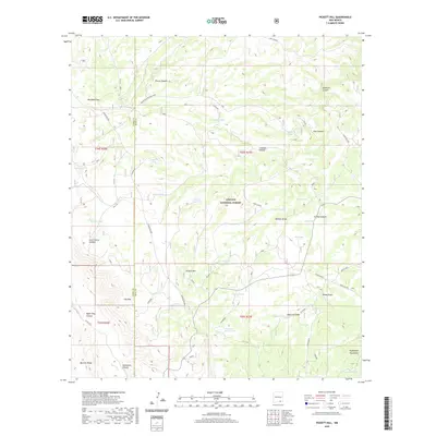
2020 Map of Pickett Hill
USGS Topo · Published 2020About this map
Lincoln National Forest encompasses much of this high-desert terrain where the border of Otero and Eddy counties follows the prominent Guadalupe Rim. The landscape is defined by an intricate network of drainage systems, including the deep cuts of Sixshooter Canyon, Upper Dog Canyon, and Last Chance Canyon. Water management is central to the land's utility, evidenced by dozens of named catchments such as Anderson Tank, Big Boy Tank, and Shattuck West Tank. These features, alongside the National Livestock Road, suggest a landscape primarily utilized for ranching and resource management within the Guadalupe Mountains range. Notable elevations like Pickett Hill and The Rim overlook a series of draws and canyons with distinctive local names like Knee Deep, Poor House, and Wildcat Draw, which help orient those navigating the backcountry of southern New Mexico.
Find a feature on this map
47 named features on this map. Tap any name to fly to it.
Don’t see what you’re looking for? This feature index may not catch every label — zoom into the map to look around manually.
Map Details
Editions of this 2020 Pickett Hill Map
This is the sole edition of this map. No revisions or reprints were ever made.
Other maps of this area

1935 · El Paso Gap
USGS Topo · 1:62,500

1936 · El Paso Gap
USGS Topo · 1:48,000

1940 · El Paso Gap
USGS Topo · 1:62,500

1940 · Bandanna Point
USGS Topo · 1:62,500

1940 · Carlsbad Caverns West
USGS Topo · 1:62,500

1943 · Carlsbad Caverns West
USGS Topo · 1:62,500

1943 · Bandanna Point
USGS Topo · 1:62,500

1943 · Texas Hill
USGS Topo · 1:62,500

1945 · Texas Hill
USGS Topo · 1:62,500

1954 · Carlsbad
USGS Topo · 1:250,000